Reviews, get directions and contact details Tumbling Waters Trail.
to add Tumbling Waters Trail map to your website;
 Fort Mountain State Park
15 km
Great place to go hiking! What a work out but beautiful! I took my two dogs and even ...
Fort Mountain State Park
15 km
Great place to go hiking! What a work out but beautiful! I took my two dogs and even ... Bear Creek Trail
19 km
Pinhoti trail is awesome, but bear creek miles 5-7 were my favorite. Ride up pinhoti ...
Bear Creek Trail
19 km
Pinhoti trail is awesome, but bear creek miles 5-7 were my favorite. Ride up pinhoti ... Emery Creek Trail
21 km
Hike is 8.4 miles now, not sure what happened with the professional reviews but the p...
Emery Creek Trail
21 km
Hike is 8.4 miles now, not sure what happened with the professional reviews but the p... Cohutta Wilderness
25 km
Well maintained trails for awesome hiiking and camping experience. We trekked along H...
Cohutta Wilderness
25 km
Well maintained trails for awesome hiiking and camping experience. We trekked along H... Boulder Falls Park and Hiking Trail
26 km
Hard to get into private community. Trails are marked and well kept. Trails are clos...
Boulder Falls Park and Hiking Trail
26 km
Hard to get into private community. Trails are marked and well kept. Trails are clos... Fall Branch Falls
31 km
Barely anyone there in mid March so it was like having the beautiful falls to ourselv...
Fall Branch Falls
31 km
Barely anyone there in mid March so it was like having the beautiful falls to ourselv... Garland Mountain Horse & Hiking Trails
32 km
The vistas were not expansive, but the trails were well maintained and the early morn...
Garland Mountain Horse & Hiking Trails
32 km
The vistas were not expansive, but the trails were well maintained and the early morn... Pine Log Creek Trailhead
34 km
Great trails and water ways. Great little gem of Georgia. Only seen a couple people o...
Pine Log Creek Trailhead
34 km
Great trails and water ways. Great little gem of Georgia. Only seen a couple people o... Amicalola Falls State Park
35 km
I try to visit this park at least once or twice a month, and I’ve never been disappoi...
Amicalola Falls State Park
35 km
I try to visit this park at least once or twice a month, and I’ve never been disappoi... AT approach trail
36 km
A proper stage setting experience for the A.T. 8.5 miles from the visitors center,...
AT approach trail
36 km
A proper stage setting experience for the A.T. 8.5 miles from the visitors center,...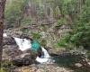 Jacks River Falls
36 km
Jacks river falls is the best waterfall in the region! Nice swimming hole about 10 ft...
Jacks River Falls
36 km
Jacks river falls is the best waterfall in the region! Nice swimming hole about 10 ft... Len Foote Hike Inn
37 km
Great, family friendly place tucked away in the woods! Reserve your spot early, becau...
Len Foote Hike Inn
37 km
Great, family friendly place tucked away in the woods! Reserve your spot early, becau... Reinhardt Biking & Hiking Trails
37 km
This is a trail system from beginner to advanced. They are labeled by number so it ea...
Reinhardt Biking & Hiking Trails
37 km
This is a trail system from beginner to advanced. They are labeled by number so it ea... Southern Terminus of the Appalachian Trail
38 km
It's a nice hike with a little up and down but not too bad. Go in early spring and yo...
Southern Terminus of the Appalachian Trail
38 km
It's a nice hike with a little up and down but not too bad. Go in early spring and yo...