Reviews, get directions and contact details for Pine Mountain Trail, West

Address: Komatsu Dr SE, Cartersville, GA 30121, USA
State: Georgia
City: Cartersville
Zip Code: 30121
opening hours
Monday: 6:00 AM – 10:00 PM
Tuesday: 6:00 AM – 10:00 PM
Wednesday: 6:00 AM – 10:00 PM
Thursday: 6:00 AM – 10:00 PMFriday: 6:00 AM – 10:00 PM
Saturday: 6:00 AM – 10:00 PM
Sunday: 6:00 AM – 10:00 PM
related searches: pine mountain trail map pdf, pine mountain cartersville ga address, pine mountain trail waterfall, pine mountain trail campsites, pine mountain cartersville ga, pine mountain bike trail, pine mountain trail fdr state park, pine mountain ga
Reviews
Great hike with a moderate incline. 2 miles round trip if you do the circuit and the Outlook. Amazing views from the top. Shaded most of the way when you have leaf coverage. 4 instead of 5 stars because trails are marked, but a little confusing. It would be better if they had maps that show your location in relation to the whole Trail at each intersection. As long as you study the map before you leave and have a planned route, you will be absolutely fine.
I have visited this Trail about once a year for the past 6 years. It is a challenging hike with incline almost all the way to the top. I have always done the West Loop. If you take the left option it is a gradual consistent incline. If you take the right option it's has more steep incline combined with some flat areas. We usually do it as a circuit.
Most recently hiked in May 2018. It was partly shaded the entire way, which was great because it was 90 degrees. The ground surface is Rocky. It is highly recommended to have hiking shoes, if not tennis shoes. This is not a hike that would be comfortable with unsuitable shoes due to the incline and rocky nature of the trail.
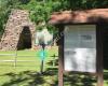
There is ample parking (and it's free!) I would guess about 60+ spaces. There is a fitness station at the parking lot, as well as an outhouse and some garbage cans. It would be nice if there was a picnic table and drinking fountain as well, but alas, there is not.
The view from the top is totally worth it. It always motivates me to stick with it and finish the hike even though it's challenging. I once took my 16 year old cousin here. She had never been hiking before, and she was nervous about it. At the end she said that it was a bit challenging, but she was really happy that she did it. She also said that it wasn't as hard as she thought it would be.
If you live in the area or a passing by, it's extremely convenient to I-75 and an amazing hike in the Atlanta area. Come check it out.
4
6 years ago (15-05-2018)
Quiet trail perfect for short hikes. Round trip to the lookout and back is about two miles with some rugged terrain. Overall there's about a 600ft elevation change. The trail offers plenty of tree coverage in the summer, and a nice open view of nearby Allatoona lake. On a clear day you can see the Atlanta skyline in the distance. It's a great place to go for a leisurely hike and also to bring your dog.
Another thing with mentioning is that the West trail intersects the East trail is you're waiting to take a loaner hike.
Parking lot is gravel but free. The are not bathrooms, but there's occasionally a porta potty available. The entrance is conveniently near the highway for easy access.
5
6 years ago (17-05-2018)
We did the entire figure eight of bother the east and west loops, along with going up to the overlook. It is a beautiful experience! Vigorous trails though, full of switch backs. The West loop trail has 2 paths, the green and the red. The red trail is easier, we ascended the red trail and descended the green. The green trail is more of a turquoise color. All trails are spray paint blazed. The east loop has a white trail, and blue trail, I think. Either way, the white trail is shorter but harder, and the other trail is longer bust doesn't ascend so harshly. It took us about 4 hours, we also sat and had lunch, and even went up to the coopers furnace picnic shelter for the bathroom. Which reminds me, there is no bathroom at the east trail parking, and only 1 port-a-potty at the west trail. Unfortunately that was covered in someone's feces on the seat, so the ladies took the TP to the woods while we kept watch. Though the picnic shelter isn't far from the east loop parking, just about a mile up the road. BRING LOTS OF WATER!!! There is some cell service, depending on your cell provider.
5
6 years ago (04-06-2018)
There is plenty of trails for biking and hiking. Very family friendly, but be careful of rocks. You may stub a toe🤕 the view is amazing, and it's all definitely worth the trip. Just come prepared and remember, the world is always at your feet.
5
6 years ago (06-05-2018)
Fun hike that's not too difficult. Takes about thirty minutes to reach the top. A lot of people go on the fourth of July to see all of the local fireworks displays, but I prefer to be closer to the action.
4
6 years ago (13-05-2018)


 Pine Mountain Trail East
2 km
Excellent hike.....moderately strenuous. Our dog loved it! Why I’m not giving it a 5 ...
Pine Mountain Trail East
2 km
Excellent hike.....moderately strenuous. Our dog loved it! Why I’m not giving it a 5 ... Pine Log Creek Trailhead
21 km
Great trails and water ways. Great little gem of Georgia. Only seen a couple people o...
Pine Log Creek Trailhead
21 km
Great trails and water ways. Great little gem of Georgia. Only seen a couple people o...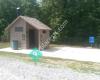 Garland Mountain Horse & Hiking Trails
24 km
The vistas were not expansive, but the trails were well maintained and the early morn...
Garland Mountain Horse & Hiking Trails
24 km
The vistas were not expansive, but the trails were well maintained and the early morn... Reinhardt Biking & Hiking Trails
25 km
This is a trail system from beginner to advanced. They are labeled by number so it ea...
Reinhardt Biking & Hiking Trails
25 km
This is a trail system from beginner to advanced. They are labeled by number so it ea... Boulder Falls Park and Hiking Trail
35 km
Hard to get into private community. Trails are marked and well kept. Trails are clos...
Boulder Falls Park and Hiking Trail
35 km
Hard to get into private community. Trails are marked and well kept. Trails are clos... Sope Creek Paper Mill Ruins
39 km
This is a beautiful trail leading to the paper mill ruins. The trail is nice and wide...
Sope Creek Paper Mill Ruins
39 km
This is a beautiful trail leading to the paper mill ruins. The trail is nice and wide... Silver Comet Trail
40 km
Excellent for bikes/rollerblades... perfectly paved path with not too much door traff...
Silver Comet Trail
40 km
Excellent for bikes/rollerblades... perfectly paved path with not too much door traff... Gold Branch Trail
40 km
Beautiful hike but a few fallen trees blocking the trail, so just be careful. Great i...
Gold Branch Trail
40 km
Beautiful hike but a few fallen trees blocking the trail, so just be careful. Great i... Oxbo Trail
40 km
What a beautiful trail right in the heart of Roswell downtown. Although you would mis...
Oxbo Trail
40 km
What a beautiful trail right in the heart of Roswell downtown. Although you would mis... Cochran Shoals Columns Drive
40 km
This is a beautiful park with historical significance and many scenic trails. My only...
Cochran Shoals Columns Drive
40 km
This is a beautiful park with historical significance and many scenic trails. My only... East Palisades Trailhead - Indian Trail Rd
44 km
We really like this trail a lot because it is a natural, unpaved trail with a nice ov...
East Palisades Trailhead - Indian Trail Rd
44 km
We really like this trail a lot because it is a natural, unpaved trail with a nice ov... Sweetwater Creek State Park
48 km
We love Sweetwater. We bought a state park pass with the idea we'd visit multiple sta...
Sweetwater Creek State Park
48 km
We love Sweetwater. We bought a state park pass with the idea we'd visit multiple sta... Northside Trail
52 km
Pleasant walking / biking trail through the woods and beside the creek. One stretch...
Northside Trail
52 km
Pleasant walking / biking trail through the woods and beside the creek. One stretch...